

What’s New at Wildlands
Staff Picks: Where to Explore This Fall
If the arrival of September in Southeastern Massachusetts has you dreaming of brisk mornings, cozy sweaters, and leaves crunching underfoot, you’re not alone. We at Wildlands Trust are already planning our autumn hikes, paddles, rides, and picnics.
Are you looking for new places to explore this fall? Our staff and volunteers have you covered! Read on for a selection of our favorite autumnal landscapes, where you just might find us leaf peeping, migratory bird watching, or spooky story telling this season.
A note on safety: hunting season begins in the fall, so please take care to protect yourself, your loved ones, and your pets while on the trails. Consult our hunting safety guidelines before you head out. (Spoiler alert: wear blaze orange!)
Happy fall from all of us at Wildlands! Please share your fall nature photos with us at communications@wildlandstrust.org. Explore our trails across Southeastern Massachusetts at wildlandstrust.org/trails.
Hoyt-Hall Preserve, Marshfield
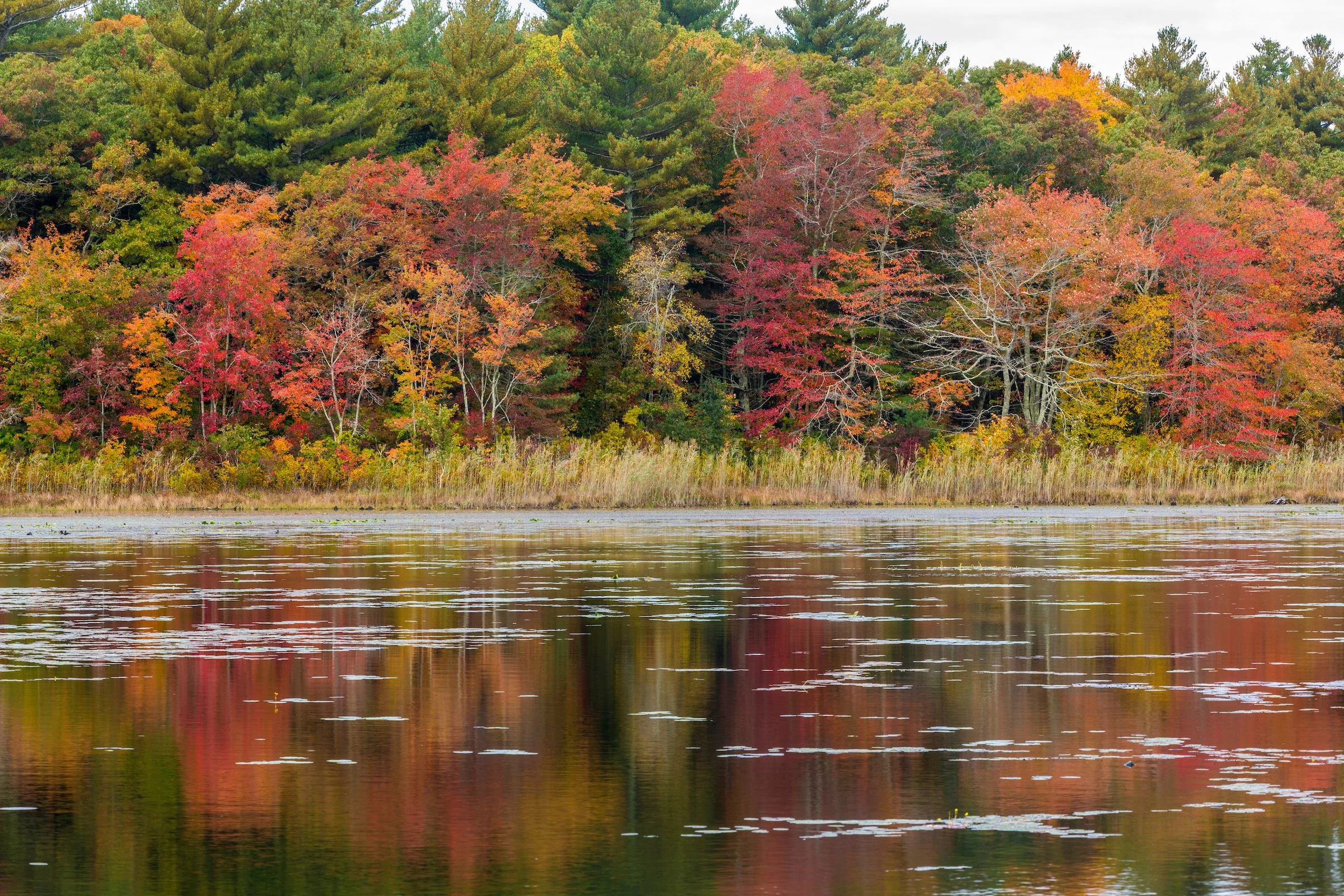
Photo by Jerry Monkman.
Trail map & property description: click here.
Rachel Bruce, Chief of Staff: The many deciduous trees show off their fall colors around Long Tom Pond, and a two-mile hike is perfect for a fall afternoon.
Tess Goldmann, Land Protection Assistant: I really enjoy Hoyt-Hall for its beautiful views of Long Tom Pond and its variety of different ecosystems you get to walk through. Plus, you can see all the red maples changing colors in October.
Great River Preserve, Bridgewater
Photo by Jerry Monkman.
Trail map & property description: click here.
Marilynn Atterbury, Key Volunteer: As the leaves begin to turn, there’s no place I’d rather be than Great River Preserve. In the fall, the landscape transforms into a landscape of color. The meadows are dotted with Joe-Pye weed, jewel plants, and goldenrod, creating a stunning display. The meadows also become a haven for monarch butterflies, which lay their eggs on the milkweed that thrives there. Meanwhile, the maples and oaks along the Taunton River put on a breathtaking show of scarlet and gold. It’s this vibrant tapestry of nature that makes Great River Preserve my favorite fall destination.
Scott MacFaden, Director of Land Protection: The Great River Preserve is a fall favorite of mine. While it shines at any time of year, it is particularly luminous in autumn because of its juxtaposition of open fields, woods, and the Taunton River. I like to leisurely hike along the edge of the fields before spending some time at the viewing platform overlooking the river—one of the most peaceful and contemplative locations in all of Southeastern Massachusetts.
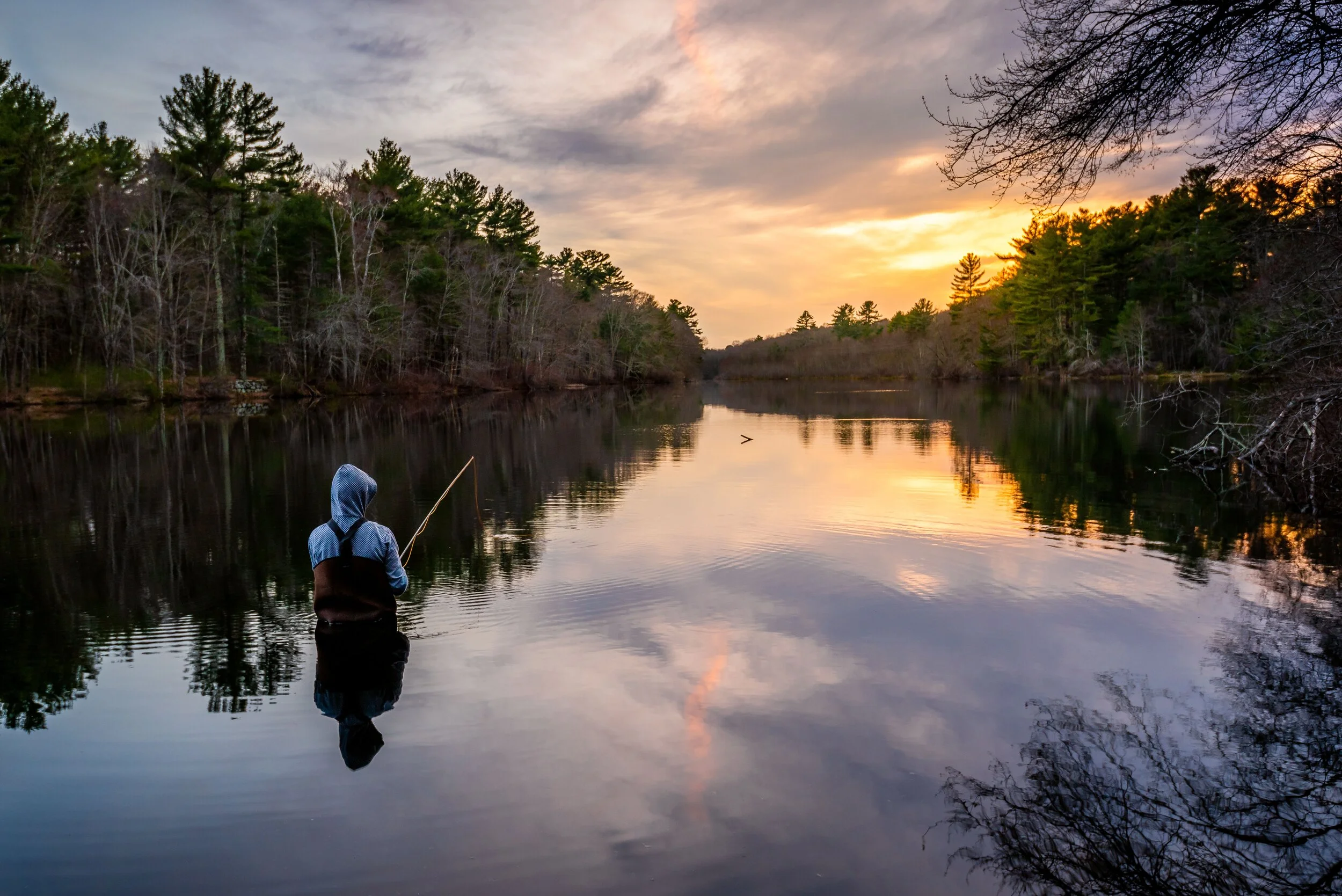
Indian Head River Trail – Pembroke, Hanover, Hanson

Photo by Andrew Lederman.
Trail map & property description: click here.
Amy Burt, Programming Coordinator: My favorite preserve is the Indian Head River Trail, a four-mile loop that encompasses Wildlands' Tucker Preserve. This time of year, you can get a great view of the river with the leaves falling while walking down a cathedral of color. Year-round, I enjoy channeling my inner goat and climbing the rocks.
Great Neck Conservation Area, Wareham

Photo by Rob MacDonald.
Trail map & property description: click here.
Skip Stuck, Key Volunteer: I like Great Neck because it has a little of everything. Uplands, ocean, marshlands, a pond full of waterfowl in the fall, and vernal pools surrounded by red swamp maples.
Kyla Isakson, Membership Manager: I love the diversity of the landscapes at Great Neck. You get a little bit of everything: ponds, farmland, pine forests, and ocean views. An underrated showcase preserve that is great year-round.
Wyman North Fork Conservation Area, Bridgewater

Photo by Rob MacDonald.
Trail map & property description: click here.
Thomas Patti, Communications Coordinator: As one of our newest public preserves, Wyman North Fork Conservation Area (a partnership between Wildlands and the Town of Bridgewater) remains a hidden gem… for now. This fall, visitors will hear bluebirds and goldfinches rustling in the meadow’s native grasses and gaze at the secluded woodlands’ vibrant foliage, hanging from the branches and reflecting off the glassy surface of the Taunton River.
Human History of Wildlands: Tucker Preserve and the Indian Head River Trail

The Indian Head River in Hanover. To the left: the Waterman Tack Factory and breached dam. To the right: Tucker Preserve. Photo by Rob MacDonald.
By Skip Stuck and Rob MacDonald, Key Volunteers
It's a cliché that a picture is worth a thousand words. In the last installment of the “Human History of Wildlands” series on Stewart/Person Preserve in Kingston, I was disappointed that despite a great deal of written information, I could find few pictures to illustrate the changes that people brought to the property. In this installment, pictures will help tell a story that words alone could not.
Wildland Trust's Tucker Preserve consists of 78 acres of forested hills and riverside in Pembroke, part of the larger, 325-acre Indian Head River Trail (IHRT) extending into Hanson and Hanover, as well. It lies very close to Wildlands' Willow Brook Farm.
Known as the Wampanoag Canoe Passage, the Indian Head and North Rivers connecting with the Taunton River watershed and eventually Narraganset Bay was a 70-mile super-highway used by native peoples for thousands of years. As a result, Tucker Preserve shares much of its pre-colonial history with Willow Brook Farm.
As Europeans arrived in the 1600s, they quickly realized the value of these rivers, not only for transportation and trade, but as a source of energy to propel burgeoning industry. Here lies the main reason why these scenes...


Photos by Rob MacDonald.
...became these scenes:


The story begins with the first mention of the property in 1632, when the Massachusetts Bay Colony governor, John Winthrop, crossed the Indian Head River at Ludden's Ford (also known as Luddam's Ford, now the site of the Elm Street bridge).
Initially, settlers farmed the land. Although it was good for livestock grazing, much of it was too rocky to produce grains and vegetables. So, they relied on the river for its abundant runs of fish (including alewives and shad for food and fertilizer) and on the surrounding forests for fuel and building materials.

Plaque at Luddam’s Ford. Photo by Rob MacDonald.
The river soon drew the settlers’ attention as a power source, with the first mention of a water-powered sawmill in 1693. Thus it began. In the 18th and 19th centuries, unlike at neighboring Willow Brook Farm, people in the Tucker Preserve area looked not to agriculture but to industry, on a scale that dramatically and irrevocably altered the landscape. The saw and grist mills were joined by an iron furnace in 1702, Smith's fulling mill (to clean and thicken wool fiber) in 1726, the Waterman and Perry tack factories in 1830, and others.
In the late 18th century, the Curtis Iron Works grew as well, supplying the needs of farming and shipbuilding. A local story relates that the factory produced the anchors for the USS Constitution. However, a factory in Hanover makes the same claim, neither town ceding the honor. By the 19th century, industry was fully in control of the area, with the Clapp Rubber Works a major employer, followed later by National Fireworks. Soon, these industries became busy enough to warrant a railroad connection known as the Hanover Branch Railway. The woods were thus transformed into a significant industrial area.

Hanover Branch Railway. The Indian Head River Trail runs along the same rail bed today. The building on the right is the Waterman Tack Factory, and the pond was formed by the dam behind Waterman, which breached in the 1938 hurricane.
So much industry sharing such a small area for two centuries came with inevitable consequences. By the early 1900s, industry in the area peaked. Afterwards, factories were closed, abandoned, and razed, and dams were breached and removed. The area returned to woodlands. Crumbling, overgrown foundations are still visible today as a reminder of the land’s industrial past. Less visible, yet even longer lasting, is the pollution remaining in the area’s soils, especially at the river bottom. Each successive industry thus left its signature on the landscape. In the 1980s, the area surrounding and downstream of the fireworks factory was identified as a potential Superfund site, and a major concern for mercury pollution.

Dam at State Street, prioritized for removal by the North and South Rivers Watershed Association’s Indian Head River Restoration Project. Photo by Rob MacDonald.
The good news is that federal, state, and local stakeholders have come together to start reversing the damage. In 1993, Sidney and Harold M. Tucker donated the Tucker Preserve property to Wildlands Trust. Together with groups like the North and South River Watershed Association, the Mattakeeset Massachuset (also known as Massachuseuk) tribe, and state and federal agencies, Wildlands helped form the Indian Head River Coalition, which created the Indian Head River Trail, a 6-mile trail network through the attractive woodlands and river you see today.
In June 2021, another coalition working to improve the Indian Head River area, the Fireworks Site Joint Defense Group, presented its report to the Executive Office of Energy and Environmental Affairs, outlining their recommendations for remediation planning. Discussions are ongoing.
Future work notwithstanding, Tucker Preserve and the IHRT now present a reasonable facsimile of its pre-industrial beauty. As you can see, however, a quick look back in time reveals a more complicated history. Without the foresight, generosity, and collaboration of concerned individuals and groups, this serene and stunning landscape could have looked very different. Figuratively and literally, its alternative outcome lies just below the surface.

Photo by Rob MacDonald.
Learn more
To learn more, visit the Tucker Preserve property description here, or visit the preserve yourself.
Also, stay informed on the Indian Head River recovery efforts via the North and South Rivers Watershed Association website:
Please also view the Town of Hanover and Pembroke Historical Society websites:
Thanks to Rob MacDonald for many of the photographs used in this piece. To see more, visit his photography website here.
Indian Head River Coalition Completes Work on Multi-town Hiking Trail Loop
By Amy Markarian, Senior Copywriter
Read Time: 2 min
The Indian Head River Trail, a popular recreational trail system spanning the towns of Hanover, Hanson, and Pembroke, just received a 3-year makeover and it's ready for spring hiking season! The latest improvements welcome new and returning visitors with an enhanced trail experience for all.
In 2017, a group of landholding entities—the Pembroke, Hanover, and Hanson Conservation Commissions, Plymouth County, North and South River Watershed Association, and Wildlands Trust—formed the Indian Head River Trail Coalition (IHRTC) to preserve the historic and natural qualities of the Indian Head River and its surrounding lands, while also encouraging passive recreation in and around the river.
In 2018, the coalition was awarded a 3-year Massachusetts Department of Conservation and Recreation (DCR) Recreational Trails Program grant to expand and improve the Indian Head River trail system. Following completion of this work in late 2021, the area currently boasts six continuous miles of trail, connecting 325 acres of conservation land along the river. The neighboring trail systems of Wildlands Trust’s Tucker Preserve and Hanover’s Iron Mine Brook are now linked with the Indian Head River Trail, offering one complete loop incorporating the various conservation properties around the river.
The DCR funding supported both trail blazing and maintenance of existing trails to create the loop. In addition, it allowed for the installation of several new features, including: map holders and trail markers to improve navigability; signage providing ecological and historical information; 800 feet of “bog board” walkways over areas of trail deterioration; benches at scenic viewpoints; informational kiosks to welcome visitors at several entrances to the trail; and printed trail maps reflecting the newest changes to the expansive trail system.
In conjunction with the Indian Head River Trail Coalition, local volunteers provided critical assistance throughout the project. Led by Wildlands Trust’s director of stewardship Erik Boyer, volunteers from The Town of Hanover, Wildlands Trust, REI, the New England Mountain Bike Association (NEMBA), and a Hanover boy scout troop assisted with trail clean up, installation of trail enhancements, ongoing trail monitoring (through Wildlands’ Adopt-a-Preserve program), and guided hikes to introduce new visitors to the trail system. Assistance with historical content pertaining to the Mattakeeset Tribe was provided by Dr. Larry Fisher.


Volunteers Cleanup Pembroke, Hanover, Hanson Preserves
On April 24, volunteers led by members of the Indian Head River Coalition banded together to remove trash along the banks of the Indian Head River, Rocky Run, and North River, as well as from the conservation properties they run through.
Volunteers initially met at Luddam’s Ford Park (Hanover) prior to breaking out into groups that would focus on five locations selected at conservation lands in Hanson, Hanover and Pembroke. Volunteers in Hanson cleaned along State Street and Rocky Run, with a notable find being an old TV they pulled out of the river. Three locations were selected in Hanover for groups to canvass, including Water Street, the Luddam’s Ford Park parking lot and Chapman’s Landing. In Pembroke, volunteers cleaned-up Luddam’s Ford Park (Pembroke) and Tucker Preserve.
In total, 25 bags of trash were removed from these areas. Items collected included everything from bottles, cans, mylar balloons, furniture cushions, and even a steel oil tank! Thank you to everyone who volunteered their time and spent the day with the Coalition in order to help keep the river system clean and healthy.


About the Indian Head River Coalition
The Indian Head River Coalition was created in 2017 for the purpose of preserving the historic and natural qualities of the contiguous conservation lands along the Indian Head River and engage the general public in taking advantage of passive recreational opportunities on these properties. The Coalition is composed of Wildlands Trust, the North and South Rivers Watershed Association, and the towns of Hanover, Hanson and Pembroke. In 2018, the group obtained a Recreational Trails Program (RTP) grant to provide trail maintenance, trail markings, amenity improvements, and new kiosks and interpretive signage along the 6-mile trail corridor that runs through and connects each property.
Indian Head River Trail Enhancements Continue Thanks to the Efforts of Many
Following centuries of changes along the Indian Head River, the towns of Pembroke, Hanson and Hanover work together with Wildlands Trust to improve the surrounding trail system with a MassTrails Program grant.
By Community Stewardship Program Manager Conor Michaud
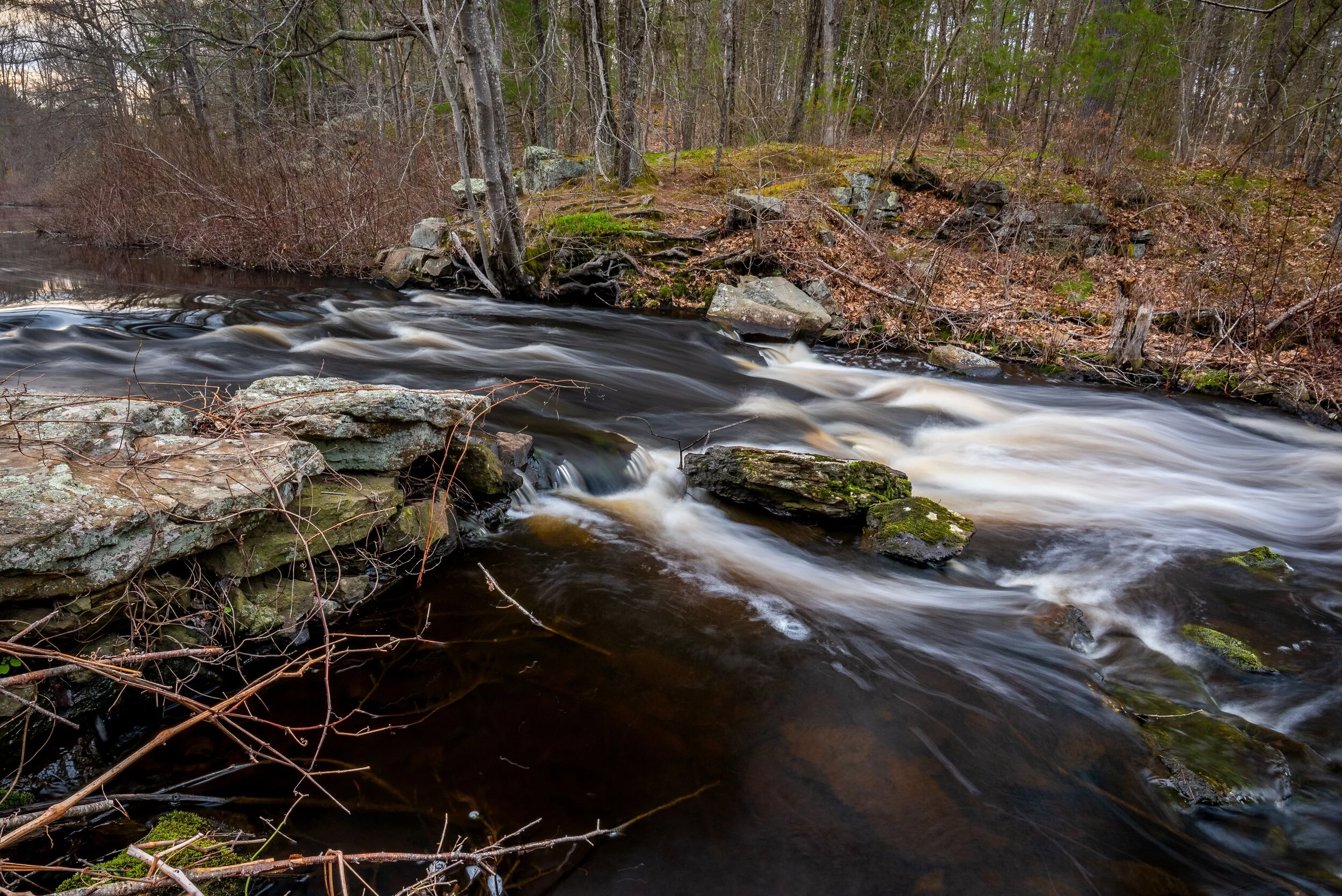
Rivers are the multi-tool of the natural world, harnessed by people, they support burgeoning populations and have played a key role in shaping our civilization. Before industrialized society, rivers were free-flowing. Unobstructed by dams and development, these waters naturally deposited nutrients and sediments along the river corridor, housed essential native breeding grounds for migratory fish and provided for a biodiverse ecosystem. Today, free-flowing rivers are globally threatened, with only several remaining in Massachusetts and the North River being the only one in Wildlands’ service region.
What remains of the Waterman Tack Factory dam rest along the shores of the IHR.
The Indian Head River (IHR), a tributary of the North River, was transformed from its free-flowing state centuries ago. Throughout the 17th century and up until the early 20th century, the IHR fueled the local economy and proved an invaluable resource. As industry left the river, mills eventually ceased production, dams collapsed and the forges cooled. The train which once ran along the shoreline is long gone, its former path converted into a nature trail some years ago. For nearly four miles, the river now flows peacefully through Pembroke, Hanover and Hanson, and in many places, large swathes of the riparian corridor and forests have been conserved to help protect this treasured habitat.
In 1993, Wildlands was gifted Tucker Preserve in Pembroke, one of Wildlands’ most popular conservation areas. The northern side of Tucker sits against the IHR, affording hikers stunning views and fishing access, while the southern upland forest showcases shady hemlock stands and old rock walls, vestiges of former agricultural land. The three towns through which the IHR flows — Pembroke, Hanover and Hanson — have each conserved land along its banks and in 2018, Pembroke received funding from the Department of Conservation and Recreation’s MassTrails Program to improve the trail system on the surrounding conservation lands and increase public stewardship along the river. Over the last two years, Wildlands has managed the IHR Trail Project for the town, working with representatives from Pembroke’s conservation commission, Hanover and Hanson’s open space committees, Hanover’s Department of Public Works, and the North and South Rivers Watershed Alliance to enhance the 4-mile trail loop encircling the IHR.
The Indian Head River flowing east from State Street.
Adequately protecting the IHR, its riparian areas and nearby upland forests requires more than trail stewardship though, it requires volunteer contributions and the devotion of local residents who will continue to assist in conservation efforts long after the MassTrails grant is complete. Throughout the IHR Project, Wildlands has focused on public outreach through guided hikes, volunteer trail work events and recruitment of volunteers to our Adopt-A-Preserve program. From these efforts, a tremendous amount of volunteer support has been shown, with over $7,000 of volunteer match time collected. Most recently, local photographer Andrew Lederman generously donated his time and skills to document the preserve’s natural beauty, as well as the remnants of the IHR’s former industrial life (featured in this article). Earlier this spring, Hanover’s Department of Public Works assisted Wildlands in creating a formal parking area along Water Street, a welcome addition as trail usage continues to grow, and this summer, Wildlands will work with a boy scout from Hanover to install new trailhead kiosks and educational signs along the trail system.
Massachusetts has a long industrial history, from the massive farming culture during the 18th and 19th centuries, to mills and factories that dammed our rivers, altered the landscape and ultimately shaped our communities. The IHR Conservation Area and the IHR Trail Project are opportunities for us to study our industrial past and the impacts of having manipulated the formerly free-flowing river. The IHR Conservation Area provides a space to track the native fish species which struggle to navigate the Luddam’s Ford fish ladder, shedding light on the impacts of dams and the benefits of protecting natural free-flowing rivers. Most importantly, the IHR Trail Project demonstrates a collaborative success and the importance of spanning town boundaries to protect what little conservation land remains in our rapidly developing towns.

The Indian Head River is an incredible resource and outdoor enthusiasts, anglers and families seek its utilities all year long. Offering miles of trails, fishing, picnicking and water craft recreation, the IHR stands out as a top nature destination in the South Shore. With the recent COVID-19 pandemic, Wildlands has seen a surge in trail users. On weekends, the parking lots are often filled and the shores are lined with hopeful fishermen and women. Wildlands reminds you to please stay on marked trails, pickup and carry out your dog’s waste, and respect fellow hikers by following social distance guidelines. Our work at Tucker Preserve and the IHR is successful because of our dedicated volunteer base and the people who respect these natural spaces. If you are interested in learning how you can help protect your conservation land please send us an email (info@wildlandstrust.org) or give us a call (774-343-5121).