

What’s New at Wildlands
Human History of Wildlands: Stewart/Person Preserve
Traveling full-circle through time

Photo of Sylvy’s Place Road sawmill. Date unknown. Click here to view excerpt from chapter “The History of Kingston.”
By Skip Stuck, Key Volunteer
What got me so excited about Stewart/Person Preserve? It's not one of the Trust's high-profile showcase preserves. Although beautiful, it's not a place of unique natural history. Stewart/Person is a small preserve, located on Sylvia Place Road in Kingston. However, its 27 acres hold a rich human history and perhaps an even more interesting future. Although small, it has an outsized history, from wilderness through several phases of development, and soon, maybe back to wilderness again. Few preserves illustrate this cycle better.
As you read this, I challenge you to think about what Stewart/Person Preserve looked like during each of its historical phases, and what it might look like ten years from now.
As always, a reminder that this account is far from comprehensive. A goal of this project is to start a conversation with the Wildlands community about the cultural pasts of our cherished natural spaces. If you or someone you know has information about Stewart/Person Preserve’s history, we would love to hear from you! Share your insight (and/or photos!) with Communications Coordinator Thomas Patti at tpatti@wildlandstrust.org.
Early History
20,000 years ago, at the height of the last ice age, this area was covered by a glacier, perhaps 1,000 feet thick. As the ice melted, the current topography of low, pine-covered, flat-topped hills and valleys was created out of the gravel, sand, and stone left behind. The valleys held wetlands like streams, small ponds, and bogs.
By 9,000 years ago, evidence shows that there were Native American people living here, at a time when the climate was similar to that found in northern Quebec today. These people thrived as the climate warmed, and by the time the Pilgrims arrived in 1620, the land was occupied by the Patuxet members of the Wampanoag Tribe. Like many local tribes at the time, the Patuxet population was reeling from a smallpox epidemic brought by Europeans several years prior.

1975 letter from Wildlands Trust co-founder and president Kathleen Anderson to Gertrude H. and O. Wellington Stewart after the Stewarts donated their 13-acre Kingston property. Click here to enlarge.
1600s and 1700s
While the Native people valued the area’s abundance of game, water, and timber, colonial settlers quickly focused on the water flowing down from the surrounding hills. Early on, iron deposits—or "bog iron"—were discovered and mined. Trees were cut down to produce the charcoal to fire furnaces and forges. But by the mid-1700s, the colonists realized that a supply of falling water was all that was needed to turn the machinery. Soon the brooks were dammed, and dams on the Stewart/Person property (plus several more downstream) created three bodies of water: Russell, Sylvia Place (sometimes called Sylvy's), and Bryant Mill ponds. In the winter, ice was harvested from the ponds. Powered by water, area factories producing cannon balls, tacks, and shoes came to be known as "Millgate." These lasted well into the 1800s. Crumbling foundations of these establishments are still visible today.
Over the years, other mills produced iron, flour, and lumber all the way down to the Jones River and eventually to Kingston Bay. On occasion, an earthen dam along this chain would breach, damaging homes and other mills downstream.
The dams dramatically altered the natural landscape, as well. In the place of historic bogs emerged ponds lined with second-growth forests of pine, oak, alder, and red maple—reflective of the Stewart/Person we see today.
1800s and 1900s
The need for water power decreased in the 1800s as oil and eventually gas and electricity took over. Factories, no longer requiring hydropower, moved on from the area. Old dams continued to degrade. In 1930, a fish ladder was built by the federal Works Progress Administration to provide an avenue for herring and other migratory fish to spawn on their historic runs. The land was becoming a quiet place once again.
In 1975, O. Wellington and Gertrude H. Stewart donated 13.3 acres to Wildlands Trust. In 2011, Martin B. and Joan Person donated an adjoining 13.48 acres, thus creating Stewart/Person Preserve. Wildlands built and maintained hiking trails, water crossings, and bridges at what has become a popular recreational destination.

Kingston village map from 1870. Click here to view excerpt from chapter “The History of Kingston.”
2000s: Completing the circle
In the early 2000s, the Trust, Town of Kingston, and state realized that the eroding earthen dams and fish ladders presented an increasing danger to houses, roads, and businesses downstream. With their original purpose gone, it was decided that they needed to be removed. In 2021, Wildlands was ordered to remove the fish ladder and breach the dam on Sylvia Place Pond. In July 2021, the Trust received a state grant of $729,000 to complete the work. Wildlands is working with engineers and permitting agencies to plan, design, and permit the project, which is expected to be started soon.
So, like many places in Southeastern Massachusetts, Stewart/Person Preserve will complete a full circle. From hilly woodlands and boggy bottoms, through 250 years of intensive use and reshaping through industrialization, the property will soon revert to something closer to where it started—a wild land.
Learn more
To learn more about the natural and human history of Stewart/Person Preserve, please visit soon to see how the land looks today, and plan to visit again in the coming years to track its fascinating future. Also, examine some of the following resources:
Our online property description: wildlandstrust.org/stewartperson-preserve
North and South Rivers Watershed Association: nsrwa.org/listing/stewart-person-preserve/
"The O.W. Stewart Preserve," Wildlands Trust, 1973, with additional notes by Reed Stewart, 1993.
“The History of Kingston.” Source unknown. View two-page excerpt here.
“Trust Preserves Wild Areas in Plymouth County.” Anne Bartlett, The Patriot Ledger. 1985.
“Wilder Times in Mill Gate.” Robert Knox, Old Colony Memorial. Nov. 8, 1990.
Human History of Wildlands: Willow Brook Farm
By Skip Stuck, Key Volunteer

People gravitate to natural beauty and diversity, whether they’re trained ecologists or not. The popularity of Willow Brook Farm is evidence of this fact.
As you will see, the history of this beloved Pembroke preserve is rich as well, and not without controversy. Before you read what follows, I want to highlight an issue that I suspect we'll see often in future editions of this series. In researching this piece, I am reminded that history is easy to write when one consults only a few sources. It becomes more difficult when we attempt to enlarge and diversify the pool of observers and accounts. In the case of this piece, you'll quickly find that history as told by the English settlers is very different from that told by the Mattakeeset, especially around the mid- to late 1600s, the time of King Philip’s War.
There is little consensus among the viewpoints of Natives and settlers. Nor should there be. The war was a bitter thing. Although not well known today, it was a horrible period, with a larger percentage of Americans, both European and Native, killed than at any other time in our nation's history. Worse yet, both sides had been friends who trusted and depended on each other only a generation or two earlier. Each side saw the conflict from its own perspective. Any single retelling of history almost always favors one person’s story to the exclusion or even denigration of another’s.
This is not to turn you off to history. Rather, it is to remind us that stories are easy to tell, but rarely as straightforward as they seem. I encourage you to examine some of the resources I've listed at the end of this piece. You might find that history has as many versions as it has tellers.
On that note, please keep in mind that this account is far from comprehensive. A goal of this project is to start a conversation with the Wildlands community about the cultural pasts of our cherished natural spaces. If you or someone you know has information about Willow Brook Farm’s history, we would love to hear from you! Share your insight (and/or photos!) with Communications Coordinator Thomas Patti at tpatti@wildlandstrust.org.
Willow Brook Farm needs your help! Wildlands Trust is seeking $20,000 in public donations to make major upgrades at this suburban sanctuary. An anonymous donor is doubling every donation under $500 and matching all others, meaning you can double or triple your impact on the land you love. Donate today.
Native American history
The area surrounding Willow Brook Farm and the Herring Brook and North River valleys has been used by Native Americans for thousands of years. The ancestors of the Mattakeeset band of the Massachusett tribe (the People of the First Light) settled in this area to use the bountiful resources it offered. The word "Mattakeesset" means "place of many fish," and the Herring River area was, and still is, home to a large alewife and river herring run each spring. Additionally, plentiful waterfowl and the land's suitability for growing maize, squash, and beans helped the tribe prosper.
After the Pilgrims landed in Plymouth, the Massachusett tribe's generosity with resources to the settlers was crucial in the colony's survival. Relationships between the two groups started strong.

Adah F. Hall House, built circa 1685. Learn more at the Pembroke Historical Society.
First European settlers
The land that was to become Willow Brook Farm was purchased in the early 1600s from Massachusett Sachem Wampatuck, known to settlers as Josiah Sagamore, by Major Josiah Winslow of Marshfield in what was known as the "Major's Purchase."
Among the earliest recorded English settlers of the Major’s Purchase land was Robert Barker, who settled in the vicinity of Herring Brook in 1650.
Relationships between the Native and English populations changed for the worse in the later 1600s, culminating in the King Philip’s War. During the war, the Mattakeeset band, although not involved in the hostilities, was forcibly removed from their lands and sent to Clark's Island in Plymouth Harbor, where it is estimated that half (possibly as many as 500) tribal members died from starvation, disease, and exposure by the war's end in 1676.
Purported to be the oldest house in Pembroke, the Adah F. Hall house, built around 1685 by Robert Barker Jr., abuts the Willow Brook property.
In the early 1800s, Robert Jr.’s descendent, Benjamin Barker, achieved significant agricultural production on the property and was reputed to be the wealthiest man in Plymouth County at the time of his death.
The property remained in the Barker family until 1914, when it was purchased by William Hurley. Hurley established Willow Brook Farm, a dairy farm and showplace for his Guernsey cows. The remains of a large dairy barn are still visible today as a foundation and milking stalls being taken over by brush and trees. Although the farm was taken out of use in the mid-20th century, its fields are still maintained by Wildlands Trust in memory of its agrarian history.
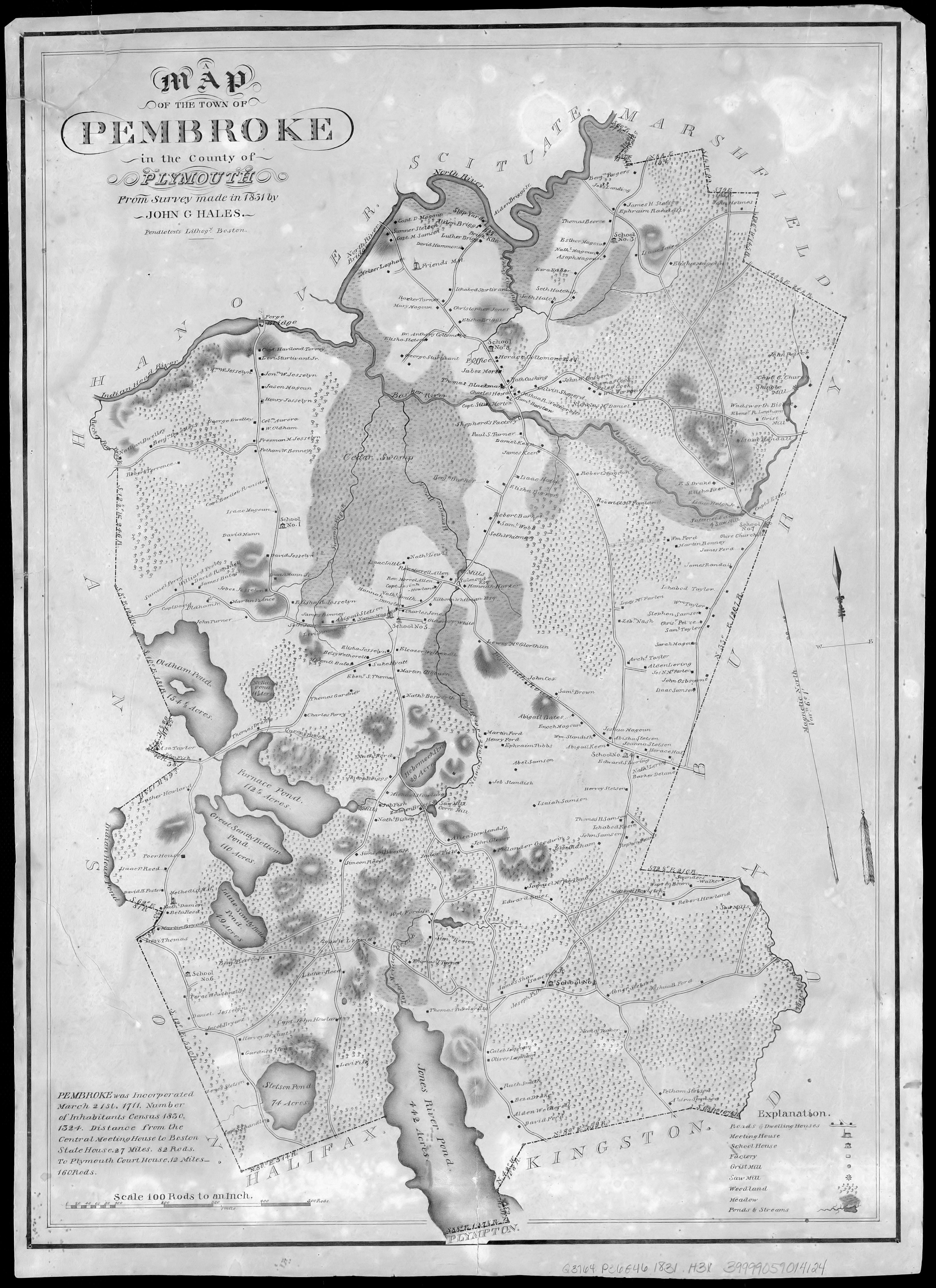
Pembroke town survey map, 1831. The Willow Brook land is represented by the spot labeled Benj Barker. Click to enlarge.
Wildlands Trust preserve
In 1997, Wildlands Trust purchased Willow Brook Farm's 73 acres with funds from an anonymous donor. Shortly thereafter, it acquired Fleetwood Farm (20 acres), Gillette-Sherman (7 acres), Lower Neck (40 acres), Missing Link (24 acres), and in 2008, the Slavin Donation (3 acres) to create today's 167-acre preserve.
Wildlands restored the property by adding a visitor parking lot and more than 3 miles of hiking trails, including boardwalks through wetland areas, an elevated viewing platform, and an informational kiosk. Today, it is one of Wildlands’ most used and appreciated preserves.
Learn More
To learn more, please visit our preserve webpage at wildlandstrust.org/willow-brook-farm. Better yet, walk the trails and enjoy the preserve’s natural and historical beauty for yourself.
An important note: History is part fact and parts perspective, personal experience, and even bias. One person's history is another's myth. Bear this in mind as you read these reference materials, especially as they relate to both Native and English histories.
To learn more about the early Native American history of the Willow Brook Farm area, as well as the Mattakeeset tribe through the present, take time to read "Our Story Not Theirs," an account by the Mattakeeset tribe itself.
Also:
The Pembroke Historical Society: pembrokehistoricalsociety.org
The Adah F. Hall House: pembrokehistoricalsociety.org/adah-f-hall-house.html
Peter’s Well, which lies just across Barker Street from Willow Brook Farm: pembrokehistoricalsociety.org/peters-well.html
History of Pembroke, Massachusetts: History of Pembroke Massachusetts | Access Genealogy
A special thanks to Hayley Leonard, Wildlands Trust AmeriCorps member, and Rob MacDonald, Wildlands key volunteer, for substantial research contributions to this account.
Human History of Wildlands: Great Neck Conservation Area

Key Volunteer Skip Stuck guides volunteers through Great Neck Conservation Area during a January 2024 trail work day.
By Skip Stuck, Key Volunteer
In 2016, as a new Adopt-a-Preserve volunteer, I was introduced to Great Neck Conservation Area by Wildlands’ Director of Field Operations, Erik Boyer. I was immediately struck by the diversity and beauty of the place. But shortly after beginning our walk-through, we got lost, something we continued to do for the rest of the day. Even though Wildlands had owned the property for over 40 years, little had been done to develop a navigable trail system. Sure, there were trails, but a spaghetti hodgepodge of them. Neighbors had created many trails beginning at their property lines and ending God-knows-where. These trails ran up driveways, across private land, and within eyesight of homes and backyards.
It was quite a jigsaw puzzle. We contacted the New England Forestry Foundation and received permission to link our trails through their property. With Erik’s permission and support from neighbors (thank you, Butch!), we set out to remap the preserve, closing some trails and opening others to create a course that would allow visitors to enjoy all that Great Neck had to offer. Through trial by fire, I learned how to build and maintain eco-conscious trails. Several months and a lot of work later, the puzzle came together, and as access to its beauty opened, Great Neck came alive for me.
We hope it does for you, too.
One quick note: because Great Neck Conservation Area comprises several historically independent parcels, distilling the area’s disjointed recent history into a unified narrative proved difficult. Many more stories could be told than you will find here. If you or someone you know has information about Great Neck’s past, we would love to hear from you! Share your insight (and/or photos!) by emailing Communications Coordinator Thomas Patti at tpatti@wildlandstrust.org.
Native American Era
Glacial history is carved into the landscape of the Great Neck (AKA Indian Neck) region of Wareham. Drumlins, kettle ponds, glacial rocks, and sandy shoreline all had something to offer to Native Americans, who utilized the area's resources for thousands of years. The many arrowheads, tomahawks, and other artifacts found here attest to its popularity among Native peoples. The conservation area’s inlets, the Crooked River from the north and Mink Cove from the south, were used for shellfishing and fish weirs. The forested hillsides were used for hunting, and lowlands for farming.
In the early 1600s, the area was inhabited by the Nepinnae Ketit band, known to the English settlers as the Agawam Indians.
Colonial Era

The original sitting room in the 1683 Burgess House. By Bill Whelan for Wareham Week.
The English began to settle this area in the 1630s. In 1666, the Plymouth Colony bought an 8,000-acre tract of land known as the Agawam Purchase from the Native Americans. In 1682, Plymouth sold the property to seven settlers in the area that would become Wareham.
Some of Wareham's earliest English settlements were on Great Neck, including the Burgess House (circa 1680), the oldest house in Wareham.
1700s
English settlers cleared much of the land for agriculture, with the lowlands devoted to vegetables and the rocky glacial uplands converted to pastures for cattle and sheep. Swamps and bogs were logged for the stands of valuable white cedar trees that grew there. Salt hay was an important resource from the surrounding marshes. Iron and charcoal were mined from bogs and woodlands, all to be smelted in the several local mills.
1800s
The Crooked River that flowed through the property was dammed in at least two places, creating a tidal area, a freshwater marsh (Jack's Marsh) that was ultimately converted to a cranberry bog, and a freshwater pond (Swan Pond) to irrigate the bog.
In the later 19th century, though cranberries continued to be grown, the early English settlement began to give way to a summer community. In 1880, the Weld and Minot families began to acquire smaller parcels in the area.
1900s
By 1900, the Welds and Minots owned most of the property on Great Neck. Among other things, they developed their own golf course, now known as Little Harbor Golf Course, one of the first in the country.
In 1909, the independently owned cranberry bogs were consolidated to become the United Cranberry Company.
In 1920, parts of the Weld and Minot land were planted with red pine and Norway spruce in hopes of selling the timber. The red pine eventually died due to a root virus. However, the spruce did well and still grows wild on Great Neck.
Great Neck Conservation Area
In 1969, Grace Minot Peirce and John Wylde donated 53 acres of the property to The Nature Conservancy on the condition that they would only hold it until a local conservation group could assume responsibility. In 1975, the land was deeded to Wildlands Trust. The Saltonstall family donated their ~60-acre property northwest of Mink Cove to the New England Forestry Foundation (NEFF).
In 1979, Wildlands also took ownership of the 26-acre Mink Cove-Elkins property.
In the 1990s, NEFF approved Wildlands’ plans to build hiking trails through their property, thus completing a 4-mile trail system and linking all the properties.
Learn more:
To learn more about Great Neck’s human history, visit our conservation area to find evidence for yourself of its Indigenous, colonial, and agricultural past. Also, explore the resources we consulted for this piece:
Visit wildlandstrust.org/events to find a schedule of group hikes and volunteer opportunities at Great Neck and other Wildlands Trust preserves.
Read our property description: wildlandstrust.org/great-neck-conservation-area
"History of Wareham.” Town of Wareham website.
"A Resource Inventory and Management Plan for the Minot-Weld Conservancy and the Mink Cove-Elkins Reservation." Caroline Norden, Wildlands Trust, 1986.
“The Welds of Harvard Yard: History Through a Family Lens.” Craig Lambert in Harvard Magazine, 1998.