
By Land Protection Director Scott MacFaden
What a long, strange year it’s been…but our land preservation work continued, nonetheless! Anyone reading this is all too aware of how this year has impacted our individual and collective health, welfare and sanity. While our work here at Wildlands has hardly been immune from the realities of the current moment, we have nonetheless adapted as best we can to those realities and continued pursuing our core mission: land preservation.
Although several projects we expected to complete this year defied our expectations, a few projects we were not necessarily counting on to close, did so. Such is the nature of our work, which continually provides us with important lessons in the virtue of patience, the value of humility and the vagaries of overconfidence.
While we are not acres-obsessive, it’s worth noting that our completed projects in 2020 added 1,200 acres to our portfolio of conserved lands—the most total acreage we have ever protected in one year in our 47-year history. We take more satisfaction, however, from the qualitative dimensions of the year’s completed projects, which included:
The completion of a pre-acquisition in Middleborough
Almost 1,000 acres of Community Preservation Act (CPA) conservation restrictions (CR) in Plymouth
The completion of our first East Bridgewater project
The finalization of a 149-acre CPA CR in Duxbury
The first two components of a very exciting multi-phased project in Hanover
The completion of a CR along the North River in Marshfield that was years in the making.
What follows are more detailed summaries of our 2020 projects:
January: Ja Mar Farm Pre-Acquisition, Middleborough
In early January, we completed our most recent pre-acquisition in partnership with the town of Middleborough: Ja Mar Farm. Encompassing 20 acres of scenic open fields along the Nemasket River, Ja Mar Farm was a long-standing preservation priority for the town because of its commanding river views, prominent location along the lower Nemasket River corridor, high-quality agricultural soils, and important habitat for multiple rare species as identified by the state’s Natural Heritage and Endangered Species Program.

The Rolling Fields of Ja Mar Farm in Middleborough.
A previous e-news article from last winter provided considerable detail into why the town needed us to pre-acquire the property, but here’s the condensed version: The town had agreed on a sales price with the former owner and had raised the funds needed to complete the purchase, but for several reasons couldn’t close on the deal within the time frame established by a purchase and sales agreement.
In order to save the property for the town, Wildlands stepped in and purchased Ja Mar Farm on the town’s behalf in October 2018 and held the property until the town had resolved the procedural issues at hand. Land trusts often work with partners, usually public agencies, on pre-acquisition projects, primarily because we operate with more flexibility than most public agencies and can typically achieve more expedited outcomes.
The partners for this project included the Native Land Conservancy in Mashpee, The Archaeological Conservancy, the Compact of Cape Cod Conservation Trusts, and town of Middleborough Conservation Agent Tricia Cassady, the project’s prime architect and catalyst. Under her guidance, the project remained viable despite numerous tribulations.
We afford a high priority to our municipal partnerships, and public-private collaborations such as the Ja Mar Farm project are testimony to the significant conservation outcomes such collaborations can help facilitate.
June: Plymouth CPA Conservation Restrictions
Wildlands acquired 975 acres of Community Preservation Act (CPA) conservation restrictions (CR) from one of our most important conservation partners, the town of Plymouth. The five CR’s and one CR amendment included three “Super CR’s”.
The completion of the restrictions is the culmination of years of proactive efforts by the town to use the resources provided by the CPA to invest in open space protection. Across multiple years and numerous town meeting cycles, the town successfully advanced dozens of open space acquisitions to completion, encompassing a wide variety of landscapes, viewsheds and wildlife habitats, including globally rare habitats such as pine barrens. Equally important, almost every acquired property helps protect Plymouth’s sole source aquifer, one of its most vital yet vulnerable natural resources.
The “Super CR’s” included:
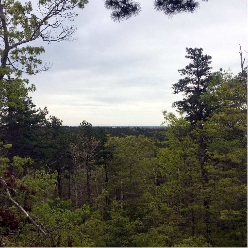
The view from Hio Hill, one of Plymouth’s highest-elevation landforms.
Forest/Large Landscape Block CR | 786.6 acres: This CR includes multiple properties of larger scale, including a 375-acre assemblage located off of Old Sandwich Road in southeast Plymouth, a 46-acre contiguous block near Great South Pond and South Triangle Pond, and an 88-acre expanse on Old Sandwich Road that includes Hio Hill, one of Plymouth’s highest-elevation landforms.
Bog Habitats CR | 94.9 acres: This CR encompasses three properties ranging in size from 64 acres to 11 acres, with each property including cranberry bogs now permanently retired from active production. As part of an ambitious effort to improve water quality in many of Plymouth’s 365 ponds, the Department of Environmental Management prioritized acquiring certain cranberry bog properties that were adversely
affecting nearby ponds, including Savery Pond and Billington Sea.

Town Brook flows freely again!
Riparian Corridor CR | 7.4 acres: This CR includes three properties that either have frontage on or are closely proximate to a brook or river, including Town Brook, Carters River and Bartlett Brook. While containing less acreage than its Super CR brethren, the properties assembled into this CR are nonetheless of considerable significance, including the site of the former “Plymco” building and dam. This property was the focus of a comprehensive restoration project initiated and led by the Department of Environmental Management that removed an unsightly and long-standing obstacle for fish passage and allows the free flow of Town Brook.
Also completed were two individual CR’s and an amendment to an existing CR:
Herring Pond Watershed CR | 53.5 acres: The town purchased this property last fall with a combination of CPA funds and a Local Acquisitions for Natural Diversity (LAND) Grant from the Commonwealth’s Executive Office of Environmental Affairs. It has extensive frontage on Roxy Cahoon Road, is almost entirely upland, includes a portion of the ancient way known as Valley Road, and directly abuts a 138-acre expanse that was formerly part of Camp Massasoit and is now town-owned open space.
Huntley Family Preserve CR | 4.6 acres: The town acquired this strategically situated property in July 2019. It has extensive frontage on Jenney Pond and connects with adjacent town land to create an expanded assemblage of open space along the lower Town Brook corridor and on the periphery of downtown Plymouth.
Ship Pond Road CR Amendment | 20 acres: This strategically situated property directly abuts and serves to expand, the 83-acre Ship Pond Road CR the town granted to Wildlands in 2005. It is also an integral component of a large corridor of protected open space situated north of Ship Pond Road and west of Old Sandwich Road.
September: Moore Conservation Restriction, East Bridgewater
As the autumnal equinox beckoned, the Moore family donated a CR on most of their homestead in East Bridgewater, encompassing 33 acres of scenic pastures, mature woodlands, extensive frontage on Salisbury Plain River, a tributary of the Matfield River and a potential vernal pool.
In 1962, the Moore family began assembling the parcels that now compose their homestead. Now on the cusp of their seventh decade of ownership and possessed of a deep commitment to ensuring that their years of careful stewardship would not eventually vanish underneath a subdivision, they determined to protect their land with a CR.
Their CR helps protect land that provides bucolic agricultural vistas from Pleasant Street that were once common in East Bridgewater, and across the region, but are increasingly imperiled by development pressures.

One of the scenic vistas protected by the Moore CR.
The CR also helps protect land along an important headwaters area in the Taunton River watershed. The Moore property has 300 feet of frontage on the Salisbury Plain River, just above its confluence with Beaver Brook. It is at this confluence where the Matfield River begins its journey toward eventually converging with the Town River. The Matfield and the Town combine to create the Taunton River, a long-treasured regional resource and since 2009 a National Wild and Scenic River.
The potential vernal pool is also of considerable interest. The Commonwealth’s Natural Heritage Program, the agency charged with documenting and protecting our rare species and natural communities, notes that “vernal pools constitute a unique and increasingly vulnerable type of wetland. Vernal pools are inhabited by many species of wildlife, some of which are totally dependent on vernal pools for their survival”. Given that reality, protecting these remaining pools has never been more urgent. Several rare species, including blue-spotted salamander, are dependent on vernal pools for successful breeding.
The Moore CR is our first completed project of any kind in East Bridgewater, and the very first CR ever completed in the town by any entity. We extend our sincere gratitude to Frank and Rosemary Moore for electing to work with us to ensure the preservation of their cherished family homestead.
October: Gifford Bog Community Preservation Act Conservation Restriction, Duxbury
The 149-acre Gifford Bog CR helps protect a sizable assemblage of town-owned open space in northeast Duxbury that includes the Wright Reservoir, scenic views, a network of hiking trails and the town’s oldest known active cranberry bog, the 21-acre namesake bog. The Gifford Bog complex also helps to protect Duxbury’s drinking water supply, as it falls within a Commonwealth of Massachusetts identified Zone II “Wellhead Protection Area” and the town’s “Aquifer Overlay Protection District”.
The land now protected by the Gifford Bog CR is part of a larger initiative by the town of Duxbury to acquire and preserve three distinct landscape assemblages formerly owned by the Merry family and possessing similar characteristics, including cranberry bogs.
The town has prioritized acquiring and preserving properties that include cranberry bogs, in part to ensure that these iconic symbols of the region’s agricultural heritage remain in active operation. Unfortunately, the Massachusetts cranberry industry is experiencing significant difficulties for a variety of reasons, and numerous bogs are no longer producing and are likely forever lost. Duxbury’s acquisition of the Gifford Bog complex and other bog complexes is a proactive strike against the current trend of decline in the region’s cranberry industry.
Congratulations to Duxbury Conservation Agent Joe Grady, Open Space committee member Pat Loring, and all their Duxbury colleagues for their outstanding work in preserving another vital component of Duxbury’s ecological and agricultural heritage.
November: Sylvester Field Woodlot Acquisition, Hanover
Last spring, Wildlands began work on the Sylvester Field Preservation Project, inclusive of four parcels: three contiguous parcels in Hanover’s historic Four Corners neighborhood with frontage on Third Herring Brook, and one in Norwell with frontage on the nearby North River. Collectively, the subject parcels compose 25 acres.
Just prior to Thanksgiving, thanks to the generosity and fervent support of a private donor, we achieved preservation outcomes for two of the three Hanover parcels by acquiring the 7-acre woodlot and a deed restriction on the adjacent 2.75-acre homestead parcel that includes a c.1854 home. We will steward the woodlot as one of our “Forever Wild” preserves, a designation we afford to properties with significant ecological values but possessed of access limitations and/or sensitive wetland resources. The homestead parcel will continue to be privately owned, but is now protected against further subdivision or unwarranted demolition.
The acquisitions of the woodlot and homestead parcel deed restriction represent the first two components of the larger Sylvester Field Preservation Project. The third and fourth components of the project are, respectively, the historic 10-acre Sylvester Field, one of Hanover’s most iconic landscapes, and the 5-acre Norwell parcel along the North River. We will have much more to report on this project as we move into 2021—watch this space!
December: Wolfe Conservation Restriction, Marshfield
For our last completed project of the year, the Wolfe family realized a long-held ambition by donating a CR on their 25-acre family homestead along the North River in Marshfield. The CR protects land with 740 feet of frontage along the river, 15 acres of saltmarsh, commanding views of a sizable stretch of river corridor, and areas identified by the Commonwealth’s Natural Heritage and Endangered Species Program as significant wildlife habitat, including Bio Map 2 Core Habitat. Areas designated as Core Habitat are critical for the long-term survival of numerous rare wildlife species and the natural communities they live within, and are thus priorities for preservation.
The immediate landscape context of the Wolfe property is highly favorable as it directly connects with two protected properties, the town of Marshfield’s 26-acre Messer Preserve and the Trustees of Reservations 68-acre Two Mile Preserve.

The North River, the Commonwealth’s only state-designated scenic river.
Seen in the prism of the larger landscape context, the Wolfe property is also notable for its location within a substantial assemblage of protected open space along the Marshfield side of the North River. Collectively comprising over 500 acres, this corridor extends from just east of the Route 3 bridge as far as one can see, and is one of the largest and most significant riparian corridor assemblages anywhere in Wildlands’ 52-community service area.
Many thanks to landowners Michael and Susan Wolfe for their unyielding commitment to preserving their land, and further expanding the mosaic of protected lands along the only state-designated Scenic River in all of Massachusetts—the North River.